Category Archives: Know Thy Monument

Hillforts, Ringforts & Hoards: The Archaeology of Ardagh, Co. Limerick

Know Thy Place Director Damian Shiels recently took the opportunity to explore some of the archaeology of the place where he grew up, near the village of Ardagh, Co. Limerick. The area is extremely rich in later prehistoric and early medieval heritage, and was the find spot of one of the most famous artefacts ever discovered on the island of Ireland.

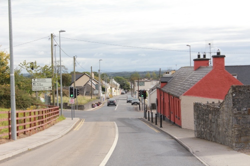
The village of Ardagh, Co. Limerick

I was very fortunate to have an ‘archaeological view’ when I was growing up in Co. Limerick. Directly across from our front door it is possible to take in c. 2,000 years of history in a single glance. The first monument to catch your eye is the impressive banks and ditches of an early medieval ringfort, one of the many such homesteads that are dotted around the area. The view is dominated by the ‘Black Hill’, which overlooks this part of Limerick and from which you can see five counties (Limerick, Clare, Tipperary, Cork and Kerry). In 1981 analysis of an aerial photograph revealed banks and ditches surrounding the summit- the tell-tale signs of a hillfort, most probably dating to the Late Bronze Age some 3,000 years ago. The inner enclosure covers some 7.5 ha (18.5 acres) while the outer enclosure demarcates a huge 20.5 ha (50.5 acres), making this one of the largest known hillforts in Ireland.
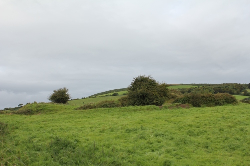
The 'view across the road': Early Medieval Ringfort in The Commons, Ardagh, with the probable Late Bronze Age Hillfort of Ballylin, 'The Black Hill', in the background

While the ringfort and hillfort were a constant sight, neither was in the same townland as our house. My claim to fame growing up was that for many years our home was the only one in the townland of Reerasta South, the site of another ringfort. I have often visited the monument; today the banks and ditches on the western and eastern sides of the fort have been ploughed away, but those on the northern and southern side still stand to an impressive height.

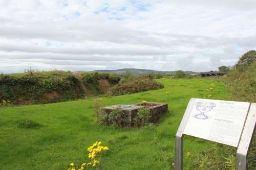
The northern bank of Reerasta Ringfort, Ardagh with interpretive signage (and cattle trough!)

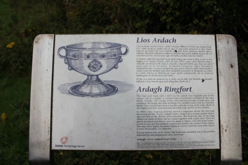
It may seem slightly odd to have once proudly proclaimed that ‘we are the only house in Reerasta South’ (and on reflection it was…), but, you see, Reerasta South had a claim to fame. One of the most notable events in the history of this part of rural Ireland took place here in 1868, when two youngsters, Paddy Flanagan and Jimmy Quin, were digging up potatoes in the ringfort. As they laboured away one of their spades struck what seemed to be a metallic object. Clearing away the soil to see what the obstruction was they discovered a small bronze chalice, which was clearly of significant antiquity. The boys wondered what else might be found, and continued the search. One can imagine their excitement as four silver-gilt brooches emerged from amongst the crop. However none of these objects were the star find- that was apparent at the moment of its discovery. Flanagan and Quin found a second chalice, this one made of precious metal and with some of the most exquisite decoration ever seen on an Irish object. This remarkable find has since become known as the ‘Ardagh Chalice’.
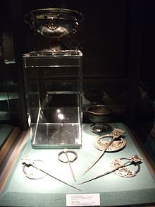
The Ardagh Hoard with the two chalices and four brooches. The stem of the smaller chalice was damaged when it was struck by a spade during its discovery in 1868

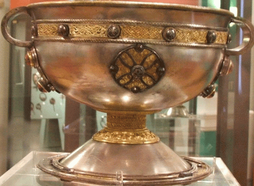
The two chalices are of 8th century date, while the brooches were manufactured sometime in the 9th century. It is possible that the objects were hidden during a Viking raid in the 9th or 10th century,with the individual who concealed them never returning to dig them up. The Ardagh Chalice is what is known as a calices ministeriales, a chalice used for giving wine to the faithful during mass. It is made up of hundreds of components and is heavily ornamented, using glass studs, silver inlays, gold filigree, a conical crystal and fabulous interlace and curvilinear designs. The main body is of silver, and the names of the apostles are inscribed on a band beneath the bowl. It is a unique masterpiece and represents the pinnacle of what could be achieved by early medieval Irish metalworking craftsmen.
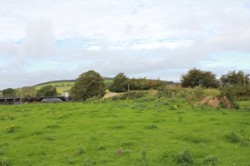
Looking north from the interior of Reerasta Ringfort, with the 'Black Hill' Hillfort in the background. The hoard is thought to have been discovered in the western part of the fort

One wonders on each visit as to the circumstances of the deposition of these amazing artefacts, and why the people who hid them never returned to claim their property. Equally thoughts turn to the two boys who in 1868  after the passage of almost 1,000 years brought these objects to light. They did not gain from their find; Paddy Flanagan was later buried in a pauper’s grave in nearby Newcastle West, while Jimmy Quin had to emigrate to Australia to try to build a life.

Detail of the interpretive sign at Reerasta Ringfort detailing the discovery of the hoard

The Ardagh Chalice itself was bought by the Bishop of Limerick who in turn sold it to the Royal Irish Academy. It is now on display in the National Museum of Ireland, where it is one of the treasures of the collection. Virtually every Irish person is familiar with the style of the chalice, even if they have never seen it in person. Every year the winners of the G.A.A. All-Ireland Senior Football Championship take home the Sam Maguire cup, which is modelled on the Ardagh Chalice and was first presented to the All Ireland Champions (Kildare) in 1928. Unfortunately the Sam Maguire has yet to return to its true ‘home’ in Co. Limerick, as the county last won the Championship in 1896…still, there is always hope for 2012!

The Ardagh Chalice on display in the National Museum of Ireland

Leave a comment

Filed under Irish Heritage, Know Thy Monument, Know Thy Place

High Crosses, Craic agus Ceol – A Very Different Archaeo-tourism Experience!
Know Thy Place Director Colm Moloney recently took the opportunity to visit the fabulous early monastic site at Monasterboice, Co. Louth for the first time. He got much more than he bargained for when he entered the site, as he explains to us below!

The Round Tower, West Cross and Medieval Church at Monasterboice

My holidays in Scotland always begin with a mad dash up the new motorway from Cork to Belfast to catch the ferry to Stranraer. My wife and I decided to attempt to break the journey on our most recent trip by visiting an archaeological site neither of us had been to previously. Our choice was Monasterboice in County Louth (about 5 minutes off the M1).

An early sundial at Monasterboice

Our visit was prompted by pure chance – we stopped when the drive got tedious and simply picked the nearest site to our location. It happened to be Monasterboice, an early monastic site located a short distance to the north of Drogheda on the main Dublin-Belfast motorway. It was one of those unpleasant days, a mixture of driving rain and gentle mist – a typical Irish summer’s day! However the weather did add a dramatic backdrop to the monastic ruins, so not to worry. There is no charge to visit the site although there is a small wooden shed near the entrance which sells books and trinkets (including a useful academic account of the monuments by Helen M. Roe).

Information Board on the High Crosses at Monasterboice

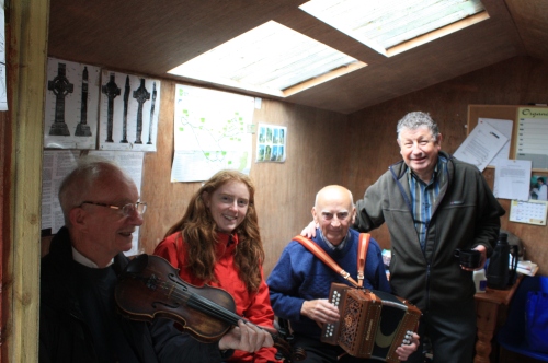
When we approached the shed we were immediately engaged in conversation by a charismatic and enthusiastic local gentleman who appeared to be in charge of the shed – I am not sure if he worked there or just hung around to entertain tourists! He immediately started to tell us about the site, its history and the best approach to visiting the ecclesiastical remains considering the inclement weather. Halfway through his spiel, a second more elderly gentleman started belting out a few traditional Irish jigs and reels on a button accordion. When the first gent realised that my wife was Scottish he gave the musician the heads up and we moved seamlessly from Irish trad to Scottish folk. 

We left the music, the site narration and the shed and headed into the ecclesiastical complex. The site was founded in the 5thcentury and is related to St Buithe. The surviving complex of structures centres on two medieval churches, a round tower and group of decorated high crosses. The site is still used as a cemetery so modern graves are interspersed with the archaeological remains.

In the Shed with my wife Louise, our host, and the Rock n' Roll Kids!

Although the churches and round-tower are of great interest, the high-crosses are spectacular. I had read about them and seen photographs, but the scale and detailed decoration of these amazing monuments is absolutely breathtaking when viewed up close and personal. Two of these are exceptional and rate amongst the best examples of their type in the country. Both probably date to the tenth century.

Me and Muiredach's Cross, Monasterboice

One of the crosses bears an inscription stating that it was erected by Muiredach and it is known as Muiredach’s Cross. This cross is simply massive, standing 5.5 m tall and heavily decorated with images from the bible including the crucifixion, the resurrection, Caen and Abel, David and Goliath and many more. One panel near the base stood out for me. This consisted of two seated men who appear to be pulling each others beards – a possible indication of a sense of comedy in the sculptor! The base is heavily decorated with Celtic knotwork.  The second of the two exceptional crosses is known as the West Cross, which although more slender that Muiredach’s Cross is also beautifully decorated. An early example of a sundial also stands amongst the crosses and gravestones.

The Beard Pulling Men, Muiredach's Cross

We left the core of the monument and headed back to the car. As we neared the exit our story-teller was waiting and dragged us back to the shed. A second musician had turned up and by now the shed was rocking to the sounds of a fiddle and button accordion. My wife was guest of honour in the shed and the duo were determined to play every  Scottish tune she could recall (we were even offered a cup of tea!). We would have stayed for hours if we didn’t have to catch a ferry. The experience left me feeling that tourism in Ireland may be missing a trick. The fusion of an amazing heritage site and living culture in the form of traditional music and story telling was truly fantastic. This is surely a model that could be rolled out more extensively by the powers that be in Irish tourism.

The West Cross, Monasterboice

6 Comments

Filed under Irish Heritage, Know Thy Monument, Know Thy Place

Hanging out at the Hag’s Bed

Know Thy Place Director Colm Moloney continues his journeys around the monuments in his local area, and brings us news of an impressive prehistoric megalith.

Labbacallee, Co. Cork- 'The Hag's Bed'

As research for KnowThyPlace, I have recently been visiting sites within a half hours drive of my home in Midleton. This weekend I visited the area around Glanworth and one site really took my breath away. Labbacallee, which translates as ‘The Hags Bed’, is one of the largest Wedge Tombs in the country and is very accessible for the archaeo-tourist (signposted off the main road from Fermoy to Glanworth).

Information board at the entrance to the site

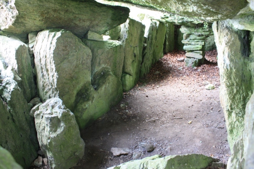
The tomb is constructed of massive stones (the largest weighs about 10 tonnes) and the monument stretches for an impressive 14 m. The interior of the chamber was excavated in the 1930s. Both human and animal bone was recovered and radiocarbon dating of the human remains indicated that the site had functioned as a burial site from about 2400 BC to around 1750 BC. Fragments of a decorated pottery vessel were also recovered. The earliest burial which was identified at a small end chamber consisted of a headless skeleton which was radiocarbon dated to 2456 – 2138 BC.

View from the rear of the monument

Wedge tombs are part of the megalithic cult that developed across Europe with the introduction of agriculture and continued into the Bronze Age, where burial chambers began to be constructed using massive stones. With the introduction of agriculture population levels increased and people had more time and resources available for undertaking such massive projects as the construction of Labbacallee. Wedge tombs dominate at the end of the megalithic tradition and are believed to be tribal burial sites which may also have had relevance to territorial boundaries. The possibility has been raised that they served as repositories for ancestral bones and served as ceremonial centers for local populations. At Labbacallee the monument is aligned with the setting sun on the equinox (22nd March and 24thof September) when a beam of light shines into the chamber – no doubt significant dates for early agriculturists!

View inside the chamber

Megalithic tombs are very durable and as such tend to survive well in the landscape. The superstitious nature of the rural population in Ireland up until recent decades has also helped to protect monuments from destruction. It is not surprising that these massive monuments attracted folk traditions over the millennium that were handed down by story tellers from generation to generation – surely they were the work of giants or magic? The local tradition tells that Labbacallee was the bed of the wife of a druid Mogh Ruith. It is common for the pre-Christian goddesses to be referred to as ‘hags’ after the introduction of Christianity. The possibility exists that a local tribal deity had a link to this site which has been preserved in the local oral tradition. Amazingly the site was already 2000 years old by the arrival of Iron Age ‘Celtic’ culture in the locality: a true monument to some of the earliest social organization, religion and engineering on the Island of Ireland.

View from the neighbouring field- watch out for the electric fence!

3 Comments

Filed under Know Thy Monument, Know Thy Place

Defending Thy Place: The Bere Island Martello Tower Complex

Bere Island is a beautiful and peaceful place. However, evidence of its military past is immediately evident when you first get a view of the island. Two Martello towers can be seen from the mainland together with a signal tower which formed a communication link between the towers.

The Cloughland Martello Tower

The Martello towers were built at the beginning of the 19th century in response to the failed French invasion of 1796. Bere Island is strategically located to provide protection for Berehaven, a favoured harbour for the British navy up until 1938. Originally there were four Martello towers with associated accommodation and a network of signal towers. Two of the Martello towers were subsequently demolished, one stood at the present location of Rerrin village and the second was positioned on the headland where the later Lonehort gun battery now stands. The surviving Martello towers are located on higher ground, one at Ardagh and the other at Cloughland. The Ardagh tower has recently been renovated and it is possible to safely enter the tower which provides excellent views over the island and the nearby mainland.

The Ardagh Martello Tower

Martello towers were constructed extensively by the British military during the late 18th and 19th century in coastal areas throughout Britain and Ireland. They were inspired by a defensive tower in Corsica at a place called Mortella, where British ships with a combined compliment of 106 guns was repulsed by two artillery pieces mounted on a circular tower which had to be eventually captured by a land force.

Rock Cut Ditch surrounding the Cloughland Tower

The Martello tower was a simple but effective design. It comprised a circular stone built tower which held a single artillery piece which could traverse a 360 degree arc and could therefore fire in any direction. The gun was mounted on a wooden traversing carriage which rotated around a pivot set in the centre of the tower. The front of the tower was mounted on wheels which traversed along a slot set on the rim of the fire step. This slot is still preserved on the Ardagh Martello tower on Bere Island. It is likely that each of the towers held a 24 pounder gun.

Firing Step with Wheel Rut

The entrance to the tower was at first floor level and opened into the barracks which accommodated the gun crews. The powder store was located in the ground floor with all three levels connected by a turnpike stairs. Rainwater was gathered in drains on the roof and channeled to the basement where it was gathered in a cistern for use in case of siege. The Cloughland tower was constructed within a circular ditch while the Rerrin example was surrounded by earthworks including a glacis which faced the seaward side. A rectangular complex of ruined buildings is located adjacent to each of the surviving towers and presumably served as less cramped accommodation.

Turnpike Stairs

As a complex, the Martello towers were a significant deterrent to attack on Berehaven and while the individual towers provided cover for ships which lay at anchor, they also covered each other from land based attacks. The Martello towers were manned until 1815 when there was no longer a threat of invasion by Napoleon.

Cistern in Basement for Collecting Rainwater

Both Martello towers are accessible to visitors to the island although the Ardagh tower is both nearer the road and can be entered through a set of wooden steps. Directions can be sought from the Islands visitor centre.

Contemporary Signal Tower viewed from the Ardagh Tower, part of the complex of Napoleonic Defences on Bere Island

3 Comments

Filed under Know Thy Monument, Know Thy Place

A Very Unusual Place! Exploring Ireland’s Only Inter-Tidal Portal Tomb

Know Thy Place Director Colm Moloney describes his recent family adventure, as he set out to find some of his local archaeology highlighted in his Know Thy Place Chart.

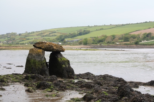
On a recent excursion with the kids in East Cork using my Know Thy Place Explorer Roll, I came across an amazing archaeological site which is a bit difficult to find but definitely worth the hassle of searching for. A portal tomb is a stunning prehistoric archaeological monument when in a normal terrestrial setting, but is simply breathtaking when set in the inter-tidal zone.  The Rostellan Dolmen in Co. Cork is only accessible at low tide, and even then can only be visited with caution. There are no signs to bring you to the site so you need an Ordnance Survey map, a compass and lots of will power!

The expedition sets out: In search of the Rostellan Dolmen

Portal tombs (sometimes referred to as dolmens) are megalithic monuments which take their name from the two large upright stones which form an entrance or ‘portal’ to the chamber of the tomb. The monuments are generally of a simple rectangular plan with a chamber formed by upright stones and the two portals. The chamber is covered by a capstone which in some cases can be massive. It is believed that portal tombs were once an integral part of a large cairn or mound. These monuments are thought to date to the Neolithic period, and from the available evidence it would appear that they served as communal graves.

Success! Our first glimpse of the Dolmen in its magnificent surroundings

The Rostellan Dolmen is located on the shoreline of Poulnalibe creek in Cork Harbour on the edge of Rostellan woods. The capstone is balanced precariously on the two portals and is no longer supported by the backstone. From the tidal marks on the stones it would appear that the monument is about two-thirds submerged at high tide. It is an unusual example of its type, and may even be a fake! It is definitely worth a visit though as it is just so weird to see it poking out of the sea.

It is a fantastic place to bring your kids if you are in the East Cork area. Some friends asked me to put directions up here:

Park at Rostellan woods. Follow the track north until you hit the shore. Follow the coast east for about 100m and you should reach the Dolmen. If you are visiting the site, check the tides and bring a good pair of wellington boots!

My kids believe it to be the resting place of an ancient warrior king and who knows, they might just be right!

Colm and the kids pose for the camera beside the 'Warrior King's' Tomb

3 Comments

Filed under Know Thy Monument, Know Thy Place

Don’t mind your blarney! Some facts about Blarney Castle, County Cork

Ireland is a country of myths and legends, and nowhere is that more true than at Blarney Castle, County Cork. Literally millions of tourists visit the site to bend over backwards and kiss the stone in order to gain the gift of eloquence. If only it was that easy! Unfortunately a great majority of those tourists fail to see the true beauty of the site when heading for their saliva drizzled jewel in the crown. The castle itself is one of the finest examples of a Irish late medieval fortification which is well worth investigating in and of itself, if you can resist the overriding desire to gain the gift of the gab!

Blarney Castle, Co. Cork

So what about the castle? Blarney Castle was constructed on an impressive limestone outcrop and was strategically sited so that it could overlook two rivers. The building of the castle has traditionally been attributed to Cormac Laidir (Cormac the strong!) MacCarthy in 1446 but it is more likely that Cormac’s brother Eoghan constructed it in the 1480s. The large tower house you see today in fact represents two phases of building; the main portion which is four storeys in height, and a smaller slightly later addition against its east wall which is five storeys high. The main building and its ‘extension’ mean that castle is L-shaped in plan. It has a vaulted first floor and the upper story is believed to have served as a chapel. The castle had outer defences that included a curtain wall, some of which still survives. A fortified tower to the east of the main castle, replete with gun loops, formed part of these defences and was probably built in the 16th century with 17th century additions; another now concealed tower is most likely late 15th century in date.

Although the majority of the visible remains we can see today are late medieval or early post medieval in date, there is evidence for an earlier fortification at the site that was most probably constructed of wood. It is thought the first stone defences were constructed in the early 13th century, and a round bastion below the tower may have its origins in this high medieval phase.

Kissing the Blarney Stone. Could you resist the temptation?

The castle was the main seat of the MacCarthys, a powerful Gaelic Irish family who were Lords of Muskerry. The use of the term ‘Blarney’ as talking a load of waffle was supposedly coined by no less a celebrity than Queen Elizabeth I of England in the 16th century. The Queen is reputed to have responded to the never ending list of excuses and plausible arguments put forward by Cormac Teige McCarthy during diplomatic discussions by stating that he was giving her ‘a lot of Blarney’. The castle was taken by force by Parliamentarian forces in 1646 after a short siege- at the time the MacCarthy’s were helping to lead the Royalist cause in Munster. The McCarthy’s reclaimed the site in 1661 following the Restoration of the Monarchy but lost it again after the Battle of the Boyne in 1690. The castle and its lands were sold to Sir James Jeffreys, Governor of Cork in 1703.

Many rumours are associated with the Blarney stone, the most famous of which is that the stone is part of the Stone of Scone which was gifted to the McCarthy’s by Robert the Bruce for providing support during the Battle of Bannockburn in 1314 – probably a load of auld blarney! The castle and its grounds are located just outside Cork City and well worth a visit for anyone travelling to the true capital of Ireland.

Leave a comment

Filed under Irish Heritage, Know Thy Monument, Know Thy Place

Discovering My Place: Kilcredan, Co. Cork

The Know Thy Place historical chart is more than just something for your wall. The information you receive also allows you to explore the archaeology of Thy Place, and serves as a guide to the location of monuments in the area. The example chart on the Know Thy Place website looks at Kilcredan, Co. Cork, Jonathan Millar’s place. Jonathan recently took the opportunity to explore some of the archaeology of the area using the chart prepared for him, and he took the time to describe his experience for the blog.

Know Thy Place Chart

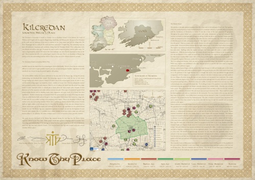
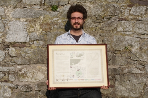
Jonathan's Know Thy Place chart for Kilcredan, Co. Cork

My Place was chosen for the first example chart because it is a fairly typical Irish townland; it has a rich history but is not ‘famous’ and is notable locally only because it houses the local parish National School. I have lived in Kilcredan for four years and in Ireland for six years altogether, since my family and I moved here from Scotland in 2004. The history of Ireland as a whole is something I am still learning and my knowledge of our local area is very fragmentary- so when I was first able to read the Know Thy Place scroll for Kilcredan it revealed many interesting details I was unaware of. I have cycled and walked around Kilcredan townland many times, but as is so often the case with the place where you live, I had never previously visited the monuments and attractions in the locality.

All this changed when I got my hands on a copy of the Kilcredan chart. I decided to select a monument listed on the chart each month to go and explore with my family.  This weekend just past, my son Louis (8) and I donned our rough clothes and adventure hats and went exploring with our cameras and a modest picnic to see what we could find at Kilcredan Church. I learned from the chart that the church and graveyard (monument 20b in my place) dated to the later medieval period and was one of two in the area. The church would have been an important focal point for the community in the past, and I imagined the generations of people who must have gone there to worship.

Know Thy Place Chart

Jonathan with a framed copy of his place, Kilcredan, Co. Cork

Upon our arrival at the church, which is now a ruin, Louis quickly spotted some of its key features. These included a variety of sculptures, many of which appear to have been intentionally defaced in antiquity, and a church building which shows the scars and markings of regular and persistent structural alterations during its life. In the burial ground we came across a diverse collection of gravestones, some of which were up to 400 years old, while more recent graves bore testament to the continued use of the site by the local community and its importance to them. We spent an hour or so exploring these memorials, and we recognised the family names of lots of our friends and neighbours, highlighting that they had ties to this townland for many hundreds of years.

Jonathan and Louis explore Kilcredan Church and Graveyard with help from their Know Thy Place chart

The Know Thy Place chart is a product that resonates particularly with Irish people and members of the diaspora who have ties to a particular town or townland, ‘their Place’. I fall into a different category, having no direct ties to the townland. However, it is now the place that I call home, and the chart has given me a much greater appreciation of the historic landscape of which my home is a part. The chart now proudly hangs on my living room wall, a constant reminder to my family and I that Kilcredan is now ‘Our Place’.

1 Comment

Filed under Irish Heritage, Know Thy Monument, Know Thy Place

Know Thy Monuments: Barrow/Tumulus

Barrows appear in the Irish landscape as low circular mounds. These are sometimes referred to as tumuli but the term barrow is dominant in modern usage. Barrows are burial mounds and can hold single or multiple burials, or in some instances act as a focus for cemeteries.  Excavated examples date from the late Neolithic to the Iron Age although they are more numerous in the Bronze Age. In general they measure between 10m and 25m in diameter (32ft to 82ft) but larger and smaller examples have been identified.

Prehistoric Barrow

A Barrow on the crest of a hill, with trees growing around its circumference

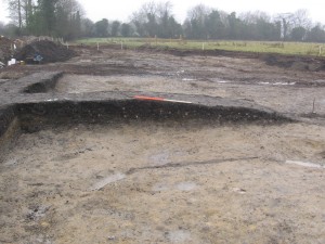
Construction usually involved excavating a circular ditch, normally with an entrance, around a central burial or group of burials. Cremation was the normal form of burial rite although inhumation was also practiced. In some cases burials were placed in simple earth cut graves while elsewhere a stone box, or cist, was constructed to entomb the burial. The up cast from the ditch was piled up in the centre to form the mound. In some instances the ditch can still be detected as an earthwork surrounding this mound. Large numbers of these monuments have been identified in recent years in Ireland in advance of road construction. In most cases they have been ploughed flat over the millennia, with only the ditch and deeper burials surviving.

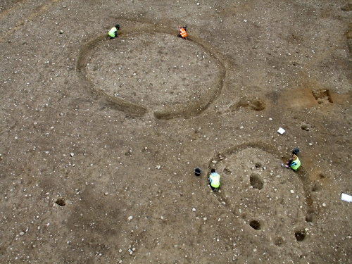
Barrow Excavation

Two Barrows under excavation, showing their tell-tale circular ditch

Considering the effort required for their construction it is generally considered that barrows represent the final resting place of the upper echelons of ancient Irish society. In some instances the inter-relationship between barrows of different sizes and adjacent burials with no covering barrow may reflect the social hierarchy of the interred population. Numerous excavations have recovered evidence for the re-use of these monuments over significant periods, sometimes several centuries, which may indicate that they served as tribal burial grounds. Within this context the sites of barrows may have been used for ritual purposes beyond burial, possibly linked to ancestral memories and rites.

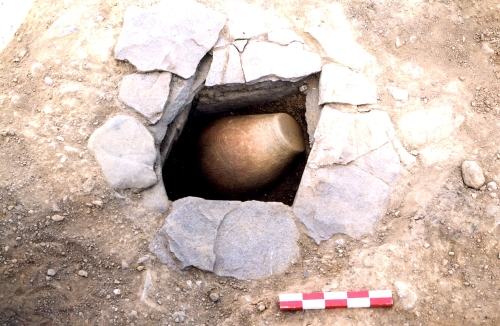
Cist Burial

A Barrow with a central cist, containing a cremation in an inverted urn

Leave a comment

Filed under Know Thy Monument, Know Thy Place

Know Thy Monuments: Fulacht Fia or Burnt Mound

Fulacht Fiadh

A spread of heat shattered stone, usually an indication of a burnt mound

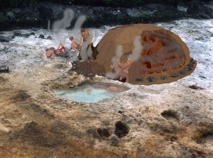
Traditionally fulachtaí  fia or burnt mounds have been interpreted as ancient cooking places dating back to the Bronze Age. In reality they are a much more complex monument with examples recorded from as early as the Neolithic and right into the Iron Age. These are the most common prehistoric field monuments in Ireland with thousands coming to light in recent years during archaeological excavations carried out in advance of the national road building programme.

Burnt Mound

The 'mound' built up as a result of heat shattered stone being discarded after use

An Irish burnt mound usually consists of a low horse-shoe shaped mound of heat shattered stone generally located in boggy ground or adjacent to a stream or river. Excavation usually reveals that the mound is associated with a number of troughs or water basins which can be simply dug into the sub-soil or lined with timber planks or stone slabs. Sometimes the foundations of structures are also identified.

Burnt Mound Trough

A wood lined trough under excavation; it was here that the water was heated

These monuments had a clear primary function; they served to heat water. The troughs or basins were dug into the ground below the water table which caused them to flood naturally. Stone was gathered in great quantities and heated in fires. The hot stone was added to the water trough(s) causing the water to heat or boil. When the hot stone hit the cooled water it shattered. After use the shattered stone was cleared out of the troughs and stockpiled adjacent to the trough, thus resulting in the typical horse shoe shaped mound.

Sweat Lodge

One interpretation of a burnt mound from Co. Waterford: a prehistoric sweat lodge

While the primary function is clear (heating water) the purpose to which the hot water was used is the subject of much debate in Irish archaeology. The traditional view of cooking places has been put to the test and it is certainly possible to cook a joint of meat in a trough. Structures found associated with burnt mounds have also been identified as saunas or sweat-houses. Other plausible interpretations include brewing, dying and tanning but the reality is that burnt mounds or fulachtaí  fia provided a means of producing hot or boiled water on an industrial scale.

1 Comment

Filed under Know Thy Monument, Know Thy Place

Know Thy Monuments: The Irish Ringfort

Over the coming months this blog will explore the different types of archaeological monuments that can be found in Thy Place, and explain their archaeology and history. We start the series with the ubiquitous Irish Ringfort, a site found in almost every place on the Island.

Irish Ringfort

A typical Irish ringfort as it appears in the landscape today

The ringfort is one of the most common Irish field monuments, with estimates on their numbers varying between 30,000 and 40,000 throughout the country. Our current understanding of these structures is that they date to the Early Medieval Period, with a peak in construction between AD 600 and AD 900. They represent the enclosed homesteads (farmhouses if you like) of the upper echelons of Irish Early Medieval society. While the term ‘ringfort’ dominates, other terms are also used such as rath, lios, caiseal and dunrath and lios are normally used to describe monuments with earthen banks while caiseal (cashel) and dun are more generally used in relation to sites with stone-built enclosures. These names are often fossilised in placenames throughout Ireland today, for example Rathmines in Co. Dublin (the Fort of Maonas) and Lisburn in Co. Antrim (the Fort of the gamblers). The decision on whether they were constructed of earth or stone was often influenced by the local landscape and the most readily available material.

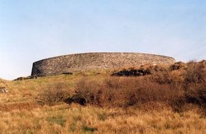
Cashel

A Cashel, a ringfort made of stone

In general ringforts, as the name suggests, consisted of a circular space enclosed by one or more banks and ditches. These generally have an internal diameter of between 15m and 35m (50ft to 115ft), but variations to this rule are known. Excavation within some of these structures has revealed that they had multiple functions. Some investigations of the interior have uncovered nothing, which led the excavators to interpret them as cattle enclosures. In general however it is believed that they housed an extended family, and the more usual arrangement consists of a large central building, usually circular in plan, with some associated out-buildings nearby. Excavations have also revealed other structures  which may have been used for agricultural purposes such as cereal drying kilns, or light industrial activities such as smithing furnaces.

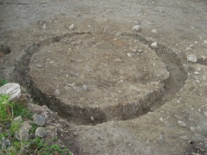
Excavation of a ringfort

A typical circular ringfort house under excavation

The early Irish law tracts set out the size and morphology of enclosures and homes for various classes of people in early Irish society. For instance the bóaire or ‘cow lord’ was entitled to a house of 8.23m, an out-house of 4.57m, a kiln, a barn, a sheep-fold, a calf-fold and pigsty.

The term ‘Ringfort’ is probably something of a misnomer, as these sites were almost certainly incapable of withstanding any form of determined attack. Although they may have provided refuge from wild animals and fast moving cattle-raiding parties, they were most likely constructed as a show of wealth by the individual in control of the area, a testament to powerful individuals which in many cases has stood the test of over 1,000 years of history.

6 Comments

Filed under Know Thy Monument, Know Thy Place