Monthly Archives: March 2012

Mapping the Irish Lost in the Titanic Disaster

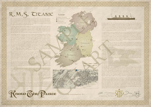
After extensive research and hard graft from all the team at Know Thy Place, we are delighted to say that our R.M.S. Titanic Chart is now complete. It tells the story of the ill-fated luxury liner’s connections with Ireland in a unique and informative way. The centre-piece is a map of Ireland, marking the home places of 129 people from the island that our researchers identified as being lost. Know Thy Place Director Damian Shiels describes some of the intriguing details we found out.

The story of the Titanic’s connections with Ireland begins with the Harland & Wolff shipyard in Belfast, where she was designed and built. We explain her building with the aid of a Belfast docks map, showing the key sites associated with the White Star Liner. One of the interesting stories we were able to uncover was the involvement a number of Irish businesses had with the Titanic’s fit-out, such as William Liddell & Company from Co. Down who produced the linen for the vessel, and the Kildare Carpet Company in Co. Laois which made the state-room carpets.

A key part of the Titanic story is that of her last port of call, Queenstown (now Cobh). A total of 123 passengers embarked from here on the doomed ship, and we look at their journey from ‘Titanic Pier’ behind the James Scott and Company offices aboard the tenders that took them to the liner anchored off Roche’s Point. As with Belfast, a map of Cobh highlights a number of the key areas in the town associated with the Titanic’s brief visit.

The Know Thy Place Titanic Chart (Copyright Know Thy Place Ltd. 2012)

The Know Thy Place Titanic Chart- Click to enlarge (Copyright Know Thy Place Ltd. 2012)

The central part of the chart’s story looks at the Irish passengers and crew who were aboard the Titanic, telling some of their stories. We spent a long time trying to generate a comprehensive list of people from Ireland who were lost when the Titanic went down, as we discovered that many publications cite wildly different numbers in this regard. There are many reasons for this- some exclude Irish crew members from their totals, while others fail to include Northern Ireland in their calculations. We found the only solution was to create our own list of individuals specifically for the chart.

We eventually generated a list of 129 passengers and crew from the island who were lost, a number that was almost certainly higher as only scant details survive for many of the crew. For the first time, the cities, towns and townlands where these people were from were used to create an at a glance image of the human cost to Ireland of the ship’s sinking. This unique map allows you to see which parts of the island were most affected, and brings home the scale and range of the impact that the loss of the Titanic must have had. For anyone interested in the Titanic Chart you can find order it direct from our website by clicking here.

6 Comments

Filed under Know Thy Place, Media

Croagh Patrick, County Mayo: St Patrick’s Place

As St. Patrick’s Day approaches once more, Know Thy Place take a look at one of the sites that is most associated with the Irish patron saint- Croagh Patrick, in Co. Mayo.

Croagh Patrick, Co. Mayo (Wikimedia Commons)

Croagh Patrick, Co. Mayo (Wikimedia Commons)

Croagh Patrick or ‘The Reek’ is one of the most famous places in Ireland. Rising to 2507 feet, it is an imposing feature on the landscape and visible for miles in all directions. It is reputedly the location of Saint Patrick’s 40 day fast, and it remains a major centre of pilgrimage to this day. On the last Sunday of July every year,thousands of pilgrims climb the mountain- many in bare feet- in commemoration and adoration of Ireland’s most famous saint. Archaeological excavations on the summit in 1994 and 1995 identified the buried foundations of a dry stone oratory which was radiocarbon dated to AD 430-890- a time not too distant from St. Patrick’s life.

The Pilgrim's Path on Croagh Patrick, Co. Mayo

The Pilgrim's Path on Croagh Patrick, Co. Mayo (Wikimedia Commons)

There is also some archaeological evidence indicating that the mountain was an important site prior to Patrick’s arrival, and was possibly a Celtic Hillfort, although further research is needed to confirm this. Tradition has it that the mountain was sacred to a Celtic deity Crom Dubh and was the location of a festival related to the harvest festival of Lugnasa. This pre-Christian Croagh Patrick was known as Cruchan Aigli. Certainly it was common for early Christian missionaries to Ireland to make good use of pre-existing traditions and beliefs to sell their own brand of religion! Indeed it has been claimed that until relatively recently some Irish-speaking locals murmured ‘In ainm Crom’ (in the name of Crom) instead of the normal Christian ‘In ainm De’ (In the name of God).

The Summit of Croagh Patrick (Wikimedia Commons)

The Summit of Croagh Patrick (Wikimedia Commons)

Undoubtedly the impressive profile of Croagh Patrick overlooking Clew Bay was always an imposing sight and legends and rituals grew around it for as long as people lived in the surrounding area. As for its association with Ireland’s patron saint, Patrick is reputed to have climbed Croagh Patrick and fasted there for 40 days and 40 nights during Lent, following the example of Christ. It is during this time that he is supposed to have banished the snakes from Ireland after they attacked him during his fast. This is a story told in every class room in Ireland. The reference to snakes is highly symbolic and one wonders if they in fact refer to the Pagan Gods. The location of Patrick’s fast, in the lair of the Pagan deities, may have been designed to indicate his imperviousness to fear of the old Gods and his victory over their powers. Whatever the truth, the story stuck and the result is now one of the most iconic images in Irish culture: pilgrims climbing the Reek holding rosary beads while deep in prayer, many in bare feet and some on their knees. One would wonder what rituals took place there before the advent of Christianity….

St. Patrick Showing the Snakes Who's Boss...

St. Patrick Showing the Snakes Who's Boss...

3 Comments

Filed under Know Thy Place, St. Patrick's Day

Know Thy Place team up with the National Museum of Ireland

We are delighted to announce that the National Museum of Ireland have decided to stock our Know Thy Place charts in their Museum Shop from this month. Now you will be able to buy County and Ireland charts while visiting some of the archaeological objects that inspired them! As professional archaeologists ourselves, it is great for the Know Thy Place team to have the quality of our work acknowledged, and we hope to continue to work with the Museum in the future! All our charts our still available from our website as well, which you can check out here.

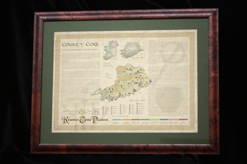
Our Know Thy Place Chart for Co. Cork, now available in the National Museum of Ireland

Our Know Thy Place Chart for Co. Cork, now available in the National Museum of Ireland

We have issued a press release to mark the occasion:

Begin a Voyage of Discovery:

Uncover the story of Ireland and your ancestral home

with Know Thy Place at the National Museum of Ireland

 Ireland has a long and glorious history. People first settled this wonderful land 9,000 years ago and have left their mark everywhere. If you’ve ever wondered what part your home place played in this wonderful story there’s good news, as visitors to the National Museum of Ireland can now explore their chosen county thanks to a unique heritage service called Know Thy Place.

The National Museum is delighted to introduce Know Thy Place’s ‘Ireland’ and ‘County’ charts, which will be available to purchase in the Museum shop from the end of March. Know Thy Place uses high quality archaeological research to provide an overview of the history and archaeology of Irish towns and regions from the earliest human settlers right up to modern times. The company’s archaeologists trawl through archives to track down every known monument in ‘thy place’ and the information is compiled into the story of your place from the earliest times, producing an end product of a beautifully illustrated wall chart which provides maps and information about the archaeology and history of the place.

Our Know Thy Place Ireland Chart, now available at the National Museum of Ireland

Our Know Thy Place Ireland Chart, now available at the National Museum of Ireland

Studying our past has come a long way in recent years, particularly with regard to Ireland and Irish heritage, and Know Thy Place is perfect for anyone who really wants to explore the archaeology of Ireland. Speaking about the charts now available at the National Museum, Colm Moloney, Director of Know Thy Place said “If you want a general overview of the archaeology of Ireland, our ‘Ireland’ chart explains the development of settlement on the island from earliest times through to the present day, featuring some of the most famous archaeological sites in Ireland as examples; while our ‘County’ charts are ideal if you have not yet identified your ancestor’s exact town land, as they look at each of the 32 counties in more detail.”

Commenting on their introduction to the National Museum, Colm said This new partnership is a real coup our team at Know Thy Place, as one of Ireland’s major archaeological institutions has recognised the great appeal and accuracy of our charts, each of which is prepared for the general reader by a professional archaeologist. We are also currently exploring the potential for the production of a range of exclusive charts for the Museum, focusing on some of the major objects and exhibitions on display, and this could prove a very exciting project for all involved.”

Know Thy Place’s ‘Ireland’ and ‘County’ charts are available, and retail for €19.99 and €39.99 respectively, pre-rolled and packaged for ease of transport from the Kildare Street shop. If you want to find out more about these and other charts available visit www.knowthyplace.com.

Leave a comment

Filed under Irish Heritage, Know Thy Place